Recreational harvest of snook for Florida’s West Coast will open March 1
The recreational harvest of snook in the Panhandle, Big Bend, Tampa Bay, Sarasota Bay, Charlotte Harbor and Southwest management regions will open March 1, and remain open through April 30. This includes all Florida state and inland waters as well as adjacent federal waters within each management region.
These regions and regulations are part of the Florida Fish and Wildlife Conservation Commission’s (FWC) holistic management approach for Florida's most popular inshore fisheries. Through this approach, seven metrics are used to evaluate the fishery by region, adding a holistic perspective to management decisions and allowing the FWC to address regional concerns. To learn more, visit MyFWC.com/Snook.
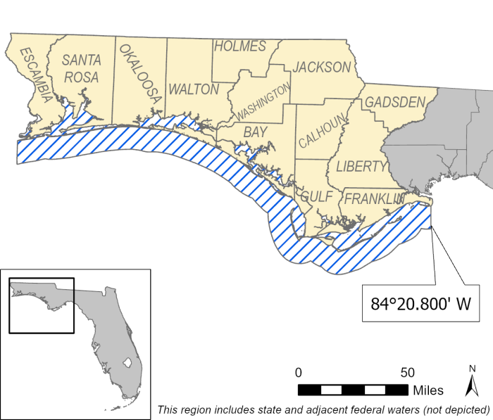
Panhandle
Open season: March 1 – April 30 and Sept. 1 – Nov. 30.
Closed season: Dec. 1 – end of Feb. and May 1 – Aug. 31.
Bag limit: One fish per person per day.
Slot limit: 28–32 inches total length.
Boundaries: The western boundary is the Florida-Alabama border and the region extends to the eastern coastal boundary at 84°20.800ꞌ West Longitude in Franklin County near Alligator Point. Includes all inland waters of the counties named and colored yellow on the map. Does not include all waters of the Ochlockonee Bay, the Ochlockonee River and its tributaries.
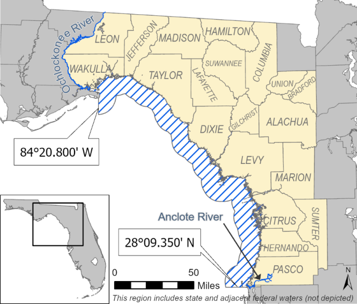
Big Bend
Open season: March 1 – April 30 and Sept. 1 – Nov. 30.
Closed season: Dec. 1 – end of Feb. and May 1 – Aug. 31.
Bag limit: One fish per person per day.
Slot limit: 28–32 inches total length.
Boundaries: The western coastal boundary is 84°20.800ꞌ West Longitude in Franklin County near Alligator Point. The region extends east and south to Fred Howard Park, near the border of Pasco and Pinellas counties. Includes all waters of the Ochlockonee, Withlacoochee and Anclote rivers and their tributaries. This region also includes all inland waters of the counties named and colored yellow on the map.
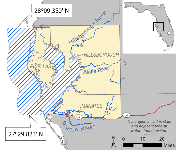
Tampa Bay
Open season: March 1 – April 30 and Sept. 1 – Nov. 30.
Closed season: Dec. 1 – end of Feb. and May 1 – Aug. 31.
Bag limit: One fish per person per day.
Slot limit: 28–32 inches total length.
Boundaries: The northern coastal boundary is Fred Howard Park, near the border of Pasco and Pinellas counties and the region extends south to State Road 64 in Manatee County. Includes all inland waters of the area colored yellow on the map. Includes all waters of the Alafia, Braden, Manatee, and Hillsborough rivers and their tributaries. Does not include the waters of Palma Sola Bay and all waters of the Anclote River and its tributaries.
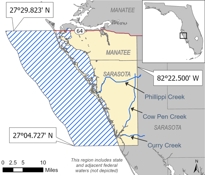
Sarasota Bay
Open season: March 1 – April 30 and Sept. 1 – Nov. 30.
Closed season: Dec. 1 – end of Feb. and May 1 – Aug. 31.
Bag limit: One fish per person per day.
Slot limit: 28–32 inches total length.
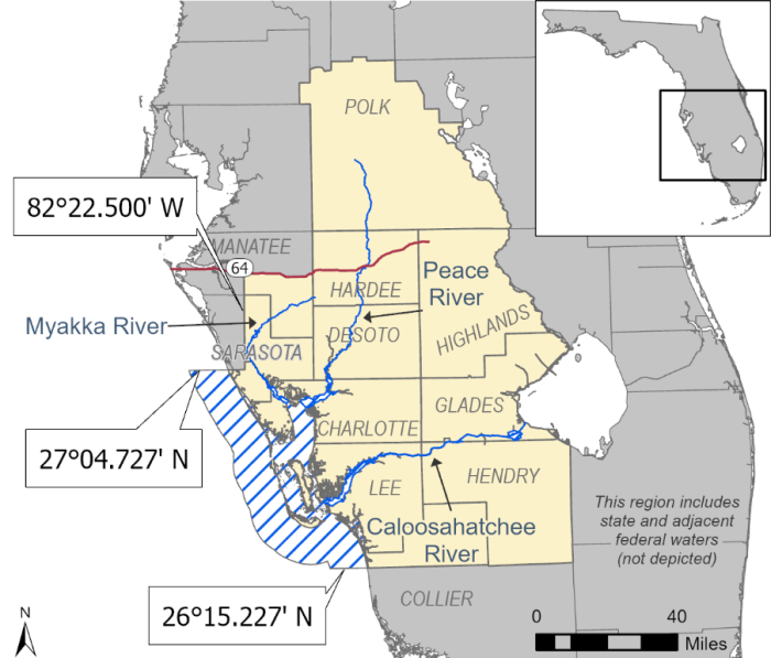
Boundaries: The northern coastal boundary is State Road 64 in Manatee County and the region extends south to 27°04.727’ North Latitude, near the Venice Municipal Airport. Includes all waters of Palma Sola Bay, Phillippi Creek, Cow Pen Slough Canal and Curry Creek. Includes all inland waters of the are colored yellow on the map. Does not include the waters of the Braden and Manatee rivers.
Charlotte Harbor
Open season: March 1 – April 30 and Oct. 1 – Nov. 30.
Closed season: Dec. 1 – end of Feb. and May 1 – Sept. 30.
Bag limit: One fish per person per day.
Slot limit: 28–32 inches total length.
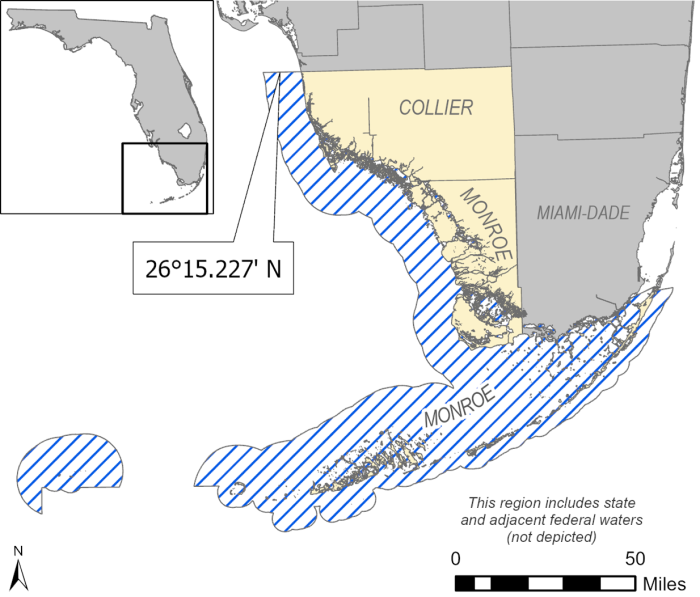
Boundaries: The northern coastal boundary is 27°04.727’ North Latitude, near the Venice Municipal Airport, and the region extends south to 26°15.227’ North Latitude, near Vanderbilt Beach Road in Collier County. Includes all inland waters of the area colored yellow on the map. Includes all waters of the Caloosahatchee, Myakka and Peace rivers and their tributaries. Does not include Lake Okeechobee.
Southwest
Open season: March 1 – April 30 and Oct. 1 – Nov. 30.
Closed season: Dec. 1 – end of Feb. and May 1 – Sept. 30.
Bag limit: One fish per person per day.
Slot limit: 28–32 inches total length.
Boundaries: The northern boundary is 26°15.227’ North Latitude, near Vanderbilt Beach Road in Collier County, and the region extends through the Florida Keys to the Monroe/Miami-Dade county line. Includes all inland waters of the area colored yellow on the map and all waters of Everglades National Park.
For more information on recreational snook regulations, visit MyFWC.com/Snook. This page includes the snook annual reviews that provide summaries of key findings from the annual evaluation of management metrics for each region.
